Sep. 15: Five Centuries of History at Old World Auctions
- by Eliane Dotson
Over 800 items representing more than five centuries of history will be offered at Old World Auctions’ September 15 sale. Although the core focus of the sale is cartography, historical documents, prints, illuminated manuscripts, and title pages will also be included. One of the earliest maps featured in the sale is a rare medieval world map based on the Rudimentum Novitiorum, a popular world history first published in 1475. This circular world map is centered on Palestine and is filled with illustrations of cities, animals, dragons, and mythological figures. This item is estimated at $18,000 - $20,000.
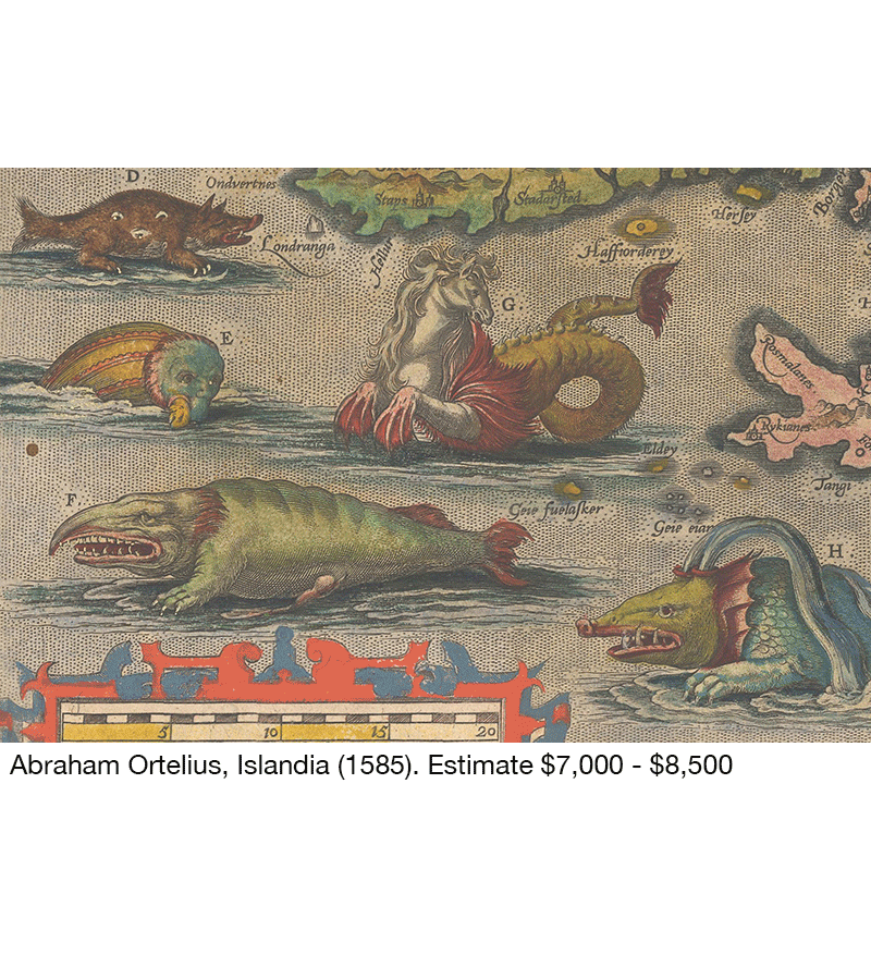
Another early masterpiece is Abraham Ortelius’ map of Iceland, which depicts the island surrounded by fanciful sea monsters, such as an aquatic hyena and the mythological hippocampus. Islandia (1585) is estimated at $7,000 - $8,500. The artistry in early mapmaking is also evident on Henry Abraham Chatelain’s Carte Tres Curieuse de la Mer du Sud(1719), a spectacular wall map celebrating the New World that includes numerous vignettes depicting native culture and indigenous flora and fauna. Chatelain’s highly sought-after masterpiece is estimated at $13,000 - $16,000.
One of the rarest items in the sale is Hunt & Randel's influential map and guidebook of the Republic of Texas. First published in 1839, this example is the 1845 edition, which was updated “from the best and most recent authorities.” The 1845 edition is exceptionally rare, with the last known offering in the 1966 Streeter sale. Hunt & Randel's Map of Texas [with] A New Guide to Texas is estimated at $28,000 - $35,000.
A set of three important maps of Havana and Batabano from Atlas Cubano (1841), the first atlas of Cuba to be printed in Cuba, will also be featured in the sale. Created by Rafael Rodriguez, these maps show extensive detail of the streets, topography, port and harbor. The lot of three maps, which are rarely seen on the market, is estimated at $4,000 - $4,750.
For those interested in more recent history, over 50 pictorial maps from the 20th century will be offered in the sale. These propaganda, advertising and tourist maps are currently one of the fastest growing categories among map collectors due to their visual storytelling. One interesting example is William Gropper's America Its Folklore (1946), which is a colorful representation of American folklore and culture that became embroiled in the post-World War II, anti-communist campaign fueled by Joseph McCarthy. Gropper’s map is estimated at $1,500 - $1,800.
Bibliophiles will be pleased to see an extensive selection of books and atlases for auction, including important American atlases by Carey & Lea (1827), Finley (1832), Tanner (1837), Greenleaf (1843), Cowperthwait (1855), and a unique cerographic atlas by Morse & Breese (1845).
View the auction catalog for this sale online beginning September 1 (www.oldworldauctions.com), with high resolution images and full condition reports on each item. Bids can be placed through September 15 at 10 PM Eastern. Register to bid at www.oldworldauctions.com/register or call (804) 290-8090 for more information.