Old World Auctions – A Cartography Specialist with an Online Auction This Month
- by Michael Stillman
The latest event from Old World Auctions will open for bidding on November 6. Old World Auctions, owned and operated by Jon and Eliane Dotson of Glen Allen, Virginia, runs its auctions strictly online. Bidding runs for two weeks, so you will be able to bid through November 20. The house specializes in maps, globes, charts, atlases and vintage graphics – cartography for short. The number of auction lots can range from several hundred to close to a thousand. Most items sell in the middle range – hundreds of dollars, though many are expected to reach the thousands and a few are hammered down below $100. Auctions are held on a quarterly basis, so the next one will come around in February.
Old World has been running auctions since 1978 (obviously not online back then). This latest one will be number 147. Bidding opens on November 6 and closes on November 20, with one wrinkle to prevent items from being stolen by last second “bidnapper” style bids. Items remain open for an additional 10 minutes after the close to allow additional offers after those placed at the last second. If none is received within 10 minutes, bidding is closed. If an additional bid is received during that period, the item is kept open for another 10 minutes, with this continuing until 10 minutes passes with no more bids. Then it closes.
Old World Auctions puts a particular emphasis on its estimates. Estimating is a science, but often the data needed can be hard to find. Some auction houses tend to estimate low, hoping to draw more bidders that way. Others may estimate high, hoping for a better price. Old World searches through past auction and other sales records to determine what is the likely price range at this time. This gets difficult for items that have not come up for sale in recent years. In that case, they will look for similar items in an attempt to figure what the market will pay for the piece. They also take into account other factors likely to affect price, such as condition, color, provenance, and edition.
Over 750 items are expected to be posted for the November sale. Along with maps and atlases, we are likely to see some historical books containing maps, geography books, antique prints, illuminated manuscripts, and reference books. All come with a 100% money-back guarantee on authenticity and condition as described. Old World offers material consigned by collectors, dealers and others around the world, and ships to customers in over 70 countries each year.
To see what is being offered this month, you can go to the Old World website at www.oldworldauctions.com.
To register as a bidder, you will find the form at this link: www.oldworldauctions.com/ssl/register.asp.
We asked Old World Auctions for some highlights for this upcoming Sale. Here are some items they suggested of particular note.
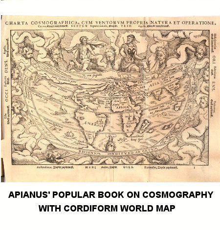
Apianus' popular book on cosmography with cordiform world map. Cosmographia [with] Charta Cosmographica, cum Ventorum Propria Natura et Operatione, by Peter Bienewitz Apianus, dated 1564. Estimate $7,000 - $8,500.
Jaillot's lavishly decorated world map in full original color. Nova Orbis Tabula, ad Usum Serenissimi Burgundiae Ducis, by Alexis-Hubert Jaillot, dated 1694. Estimate $4,500 - $5,500.
One of the most decorative maps of the north pole. Poli Arctici, et Circumiacentium Terrarum Descriptio Novissima, by Hondius/de Wit, circa 1715. Estimate $1,900 - $2,200.
The miniature Speed dual atlas. A Prospect of the Most Famous Parts of the World [bound with] England Wales Scotland and Ireland Described…, by Speed/Kaerius, dated 1666-68. Estimate $3,750 - $4,500.
Scarce map of colonial northeastern United States. Nieuwe en Nauwkeurige Kaart van een gedeelte van Noord Amerika, behelzende Nieuw Engeland, New York, Pensylvania, New Jersey, Connecticut, Rhode Island, een Stuk van Virginia, Kanada en Halifax, by Peter Kalm, circa 1772. Estimate $1,400 - $1,800.
A seminal map of the southeast and early American cartography. Virginiae Item et Floridae Americae Provinciarum, Nova Descriptio, by Jodocus Hondius, published 1619. Estimate $2,400 - $3,000.
One of six maps most desirable for a Texas collection according to Streeter. Carta Esferica que Comprehende las Costas del Seno Mexicano Construida de Orden del Rey en el Deposito Hidrografico de Marina, by Direccion de Hidrografia, dated 1803. Estimate $8,000 - $12,000.
Superb example of Dutch cartographic design and engraving in full original color. Britannia Prout Divisa fuit Temporibus Anglo-Saxonum, Praesertim Durante Illorum Heptarchia, by Jan Jansson, circa 1646. Estimate $3,000 - $4,000.
Elaborate map of the holy land, illustrating the life of Abraham. Abrahami Patriarchae Peregrinatio, et Vita, by Abraham Ortelius, published 1590. Estimate $3,000 - $3,750.
Bold map of Japan based on Adrian Reland's map of 1715. L'Empire du Japon, Tire des Cartes des Japonnois, by Henry Abraham Chatelain, circa 1719. Estimate $1,500 - $1,700.